Transport Infrastructure
The results of geodetic surveys are widely used in the construction and operation of transportation facilities. The method of surveying is of great importance. The most modern and productive method for geodetic surveys is terrestrial laser scanning.
Terrestrial laser scanning of transportation infrastructure objects is performed when:
- geodetic surveys for design,
- control of construction and installation, performing executive survey, comparing the actual object with the project,
- measuring volumes of: excavated soil, bulk material storage, earthworks.
Conducting geodetic surveys
The undeniable advantage of survey data obtained with the help of laser scanning is their initial three-dimensional character. That is, in addition to the traditional topoplan with elevation marks, it is possible to obtain a highly detailed digital elevation model (DEM), which greatly facilitates further design in AutoCAD Civil3D, CREDO or other CAD software.
When carrying out construction works with the help of modern systems of construction machinery control, laser scanning is the most expedient means of measurement, because both survey data and executive survey is carried out at once in three-dimensional form, which greatly simplifies the process of design and construction control.
Laser scanning acquires special importance in the design of reconstruction and repair. Complex measurements at the existing object are considerably simplified when using highly automated laser scanning
Control of objects under construction (built), comparison of the actual object with the project
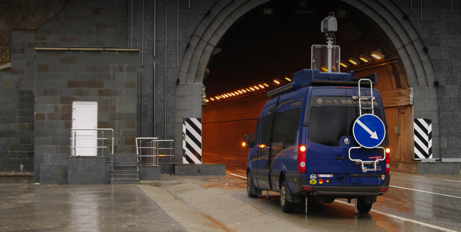
When controlling the construction of roads, bridges, tunnels and railroads, it is advisable to use terrestrial laser scanning. The main advantage of laser scanning in this case is contactlessness and efficiency of the data obtained. A busy transportation section can be measured without stopping traffic, safely for the operating personnel and equipment. The use of 3D laser scanning also allows minimizing the influence of human factor due to a high degree of automation of the data collection process.
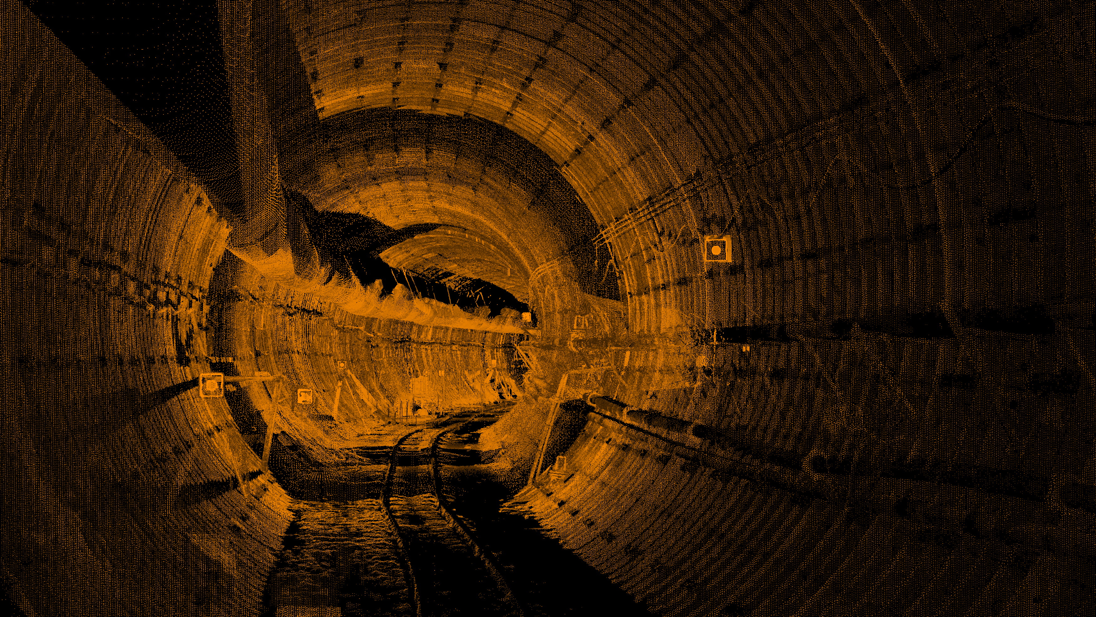
To build an actual “as is” three-dimensional model of the controlled object in cases where the objects of control are not units of points, but hundreds and thousands of geometric parameters, it is advisable to use laser scanning. According to this model, with high accuracy corresponding to reality, it is possible to carry out measurements in comfortable office conditions, without traveling to the object. Often certain parameters on the real object simply cannot be measured, while on the virtual model they are taken in seconds.
An important aspect is a high degree of automation in scanning data processing. It is possible to build, for example, a set of cross-sections in 20 m, 2 m, 20 cm from a scanned model of a linear object, discreteness is not important.
Measurement of volumes: excavated soil, bulk material stockpiles, excavation works
During excavation work, it is sometimes difficult to calculate the volume of soil actually moved. Operational measurements with a laser scanner can do the job. By accurately recording the surface microrelief, the scanner determines the volume of excavated/compiled soil and bulk material.
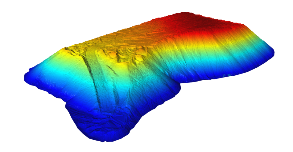
In case of cyclic nature of works there is a possibility to compare DEMs of different periods. In this case not only the volume of moved material is calculated, but also mapping – determination of the location of the occurred changes.
Final result format
Upon completion of works the following materials can be handed over to the customer:
- terrain plan M1:1000, M1:500 and larger,
- DEM in DWG, DGN, STL, OBJ, VRML, X3D, U3D, PLY formats,
- point model (point cloud),
- set of various measurements in tabular form (coordinates, distances, radii, areas, volumes, slopes, etc.),
- map of deviations of the real object from the project,
- three-dimensional model in a game environment (“wanderer”), a video clip with a hall,
- report on the work performed, including a report on the construction of the survey foundation network, a report on georeferencing, a report on accuracy check.
Laser scanning services
Trimetari Consulting has extensive experience in laser scanning and modeling of transportation infrastructure objects. Information about part of completed projects is available in the Projects section. To obtain a complete reference list, confirming the company’s qualification, to order laser scanning services, to calculate the cost of laser scanning, please contact us through the Contact Us page.