Power, Process and Plant
When designing the reconstruction of industrial facilities, accurate and up-to-date spatial data are required, information on the geometry of the reconstructed production is needed. Such data can be obtained by vectorizing drawings, usually design drawings, outdated and incomplete, or by conducting a set of geodetic surveys at the site. Often drawings were lost, damaged or absent. In such a case surveys are necessary, it is necessary to quickly and accurately measure a complex structure, such as a shop, industrial site and present the result in digital three-dimensional form, a result that can be used as a basis for design in CAD-system.
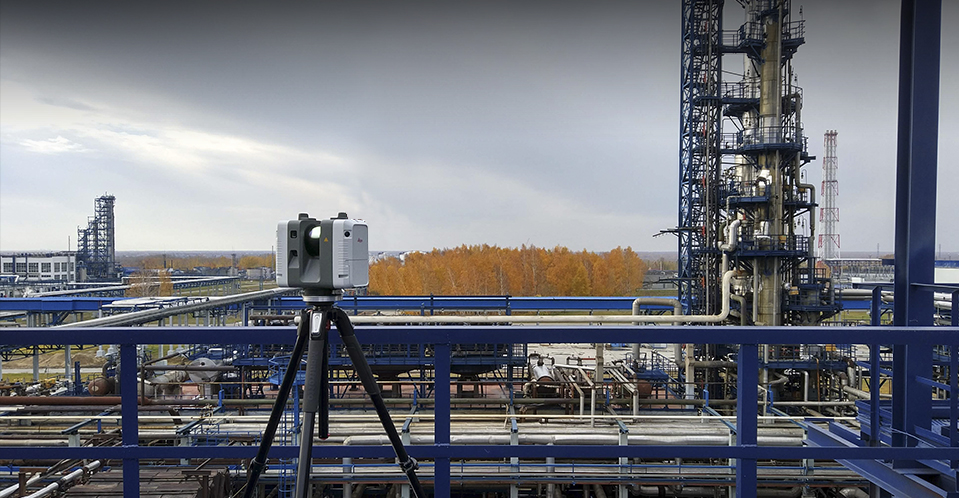
At present there is a technology that can be used to solve the problem of obtaining an accurate three-dimensional model of a complex structure – it is the technology of three-dimensional terrestrial laser scanning.
Terrestrial Laser Scanning (TLS) is a technology for obtaining an accurate three-dimensional digital model of objects that is unparalleled in terms of speed and productivity.
Applications of 3D laser scanning in industry
Laser scanning of industrial objects is performed during:
- reconstruction of workshops and industrial sites,
- design and construction of new facilities,
- calibration of oil tanks,
- creation of 3D-model of the enterprise for ACS in order to increase the efficiency of operation,
- modernization, design, construction of ships and platforms.
The largest number of projects involving laser scanning is carried out in the following industries:
- oil and gas,
- chemical,
- metallurgy,
- energy,
- pulp and paper,
- pharmaceuticals,
- shipbuilding and offshore.
Reconstruction of workshops and industrial sites
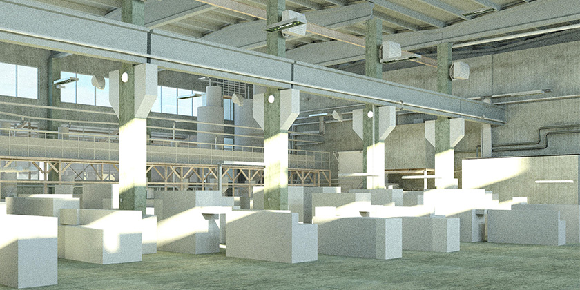
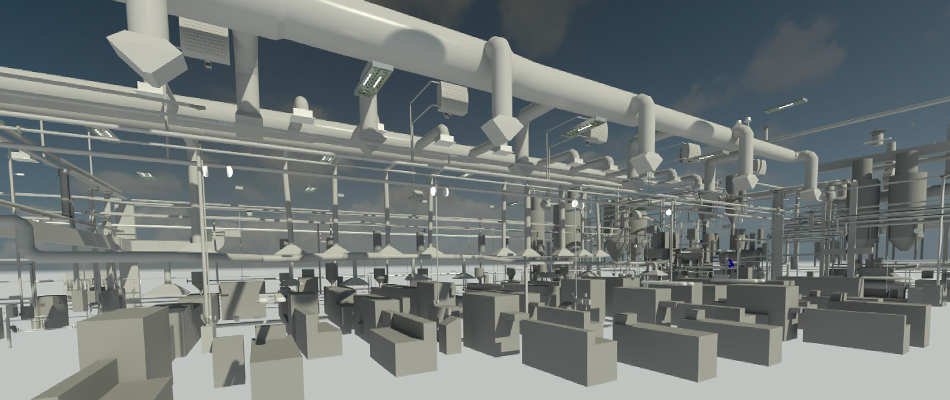
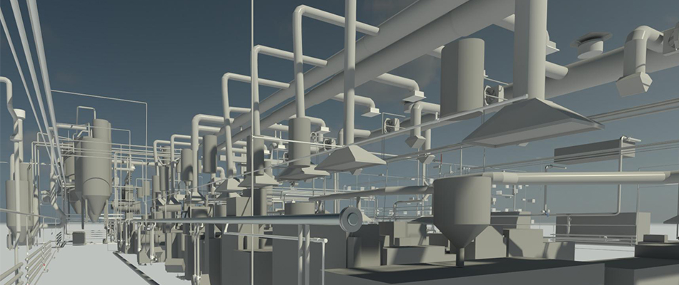
When remodeling shops and industrial sites full of technological equipment, spatial information about existing technological equipment and building structures is of great importance. Such information can be stored and processed in the form of flat drawings on paper (which, moreover, often do not correspond to reality), or in the form of an actual three-dimensional model. 3D model of the existing production allows not only to correctly design the reconstruction, but also significantly (from 0.3% to 10%) reduce the cost of eliminating conflicts at the stage of construction and installation works, which ultimately reduces the cost and speeds up the entire process of reconstruction of the enterprise.
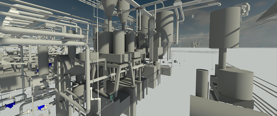
There are several ways to build a 3D model of existing technological equipment, all of them are somehow connected with measurements. The most modern and effective of them is the method of terrestrial laser scanning. The method is widely used for complex measurements in three-dimensional space. The effect of 3D scanning application is appreciated by design organizations of Russia and foreign countries. Not a single large-scale project on reconstruction of an industrial facility without laser scanning is impossible in the West.
In just 10 years laser scanning technology has changed the ideas about geodetic measurements of industrial objects and allowed to simplify and reduce the cost of reconstruction. AVEVA, Intergraph, Bentley, Autodesk – the world’s largest CAD manufacturers include functions for working with laser scanning data in their software. Knowledge of the existing production “AS IS”, i.e. “as is”, obtained not from old drawings, not by hundreds of manual measurements, but by means of a high-performance 3D laser scanner, can significantly improve the quality of design and save money at the construction stage.
Construction of new facilities
When controlling the construction of industrial and civil buildings and structures, it is advisable to use 3D laser scanning instead of traditional optical and satellite measurement tools.
The main advantage of laser scanning in this case is the efficiency of the obtained data. On objects with high construction rates, high density and a large number of control objects it is necessary to keep a team of specialists, who carry out geodetic measurements on a daily basis. In addition to the high cost of such works, the human factor is inevitable, which leads to delayed deadlines and increased cost of construction works. The use of 3D laser scanning allows to minimize the human factor due to the high degree of automation of the data collection process.
Monitoring of construction and installation works with the help of laser scanning allows to regularly update information on the current state of construction, control the progress of works, and promptly adjust the schedule. 3D scanning allows you to quickly get an answer not only to the question “what is built?”, but also to the question “how is it built?”. Combining the “as is” or “as built” models with the “as designed” project model allows to identify collisions, construction errors at an early stage, reduce the risks of exceeding the construction schedule and budget.
Today laser scanning is the most effective technology for obtaining a three-dimensional model of a building or structure at any stage of construction for use in BIM system.
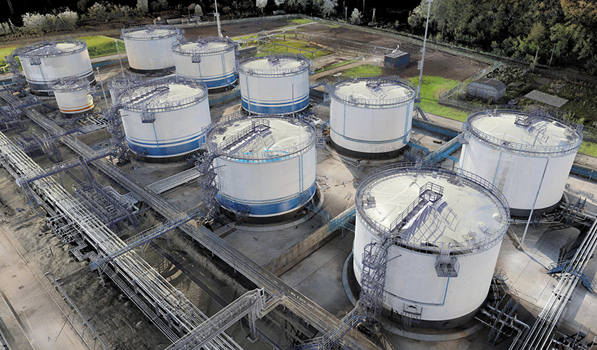
Oil tank calibration.
After construction or renovation of an oil tank (both stationary and placed on a river or marine vessel), there is a need to build tare tables that determine the dependence of liquid volume on the fill level. The speed of obtaining spatial geometric information about the tank by laser scanning method allows to create tare tables faster and more accurately than existing manual methods. In addition, laser scanning greatly simplifies tank geometry control.
Automated enterprise management systems
When operating enterprises associated with complex, distributed in space production, it is advisable to use automated enterprise management systems (AEMS) that use three-dimensional models of production, created by 3D laser scanning. The models are used for:
- enterprise operation planning,
- training of employees of enterprises, including remote ones, associated with increased danger,
- forecasting of emergencies, planning of liquidation of consequences of emergencies,
- solving safety issues,
- equipment inventory.
Final result format, CAD compatibility
Upon completion of laser scanning works the following materials can be handed over to the customer:
- 3D geometric solid model of industrial equipment in AVEVA PDMS, E3D, Intergraph SmartPlant, Intergraph SmartMarine, Bentley Microstation, Autodesk AutoCAD, Revit, etc. formats,
- intelligent 3D model in AVEVA PDMS, Intergraph SmartPlant formats,
- point model (point cloud),
- topographic plan M1:1000, M1:500, M1:200 and larger, a set of drawings (plans, sections), schemes, all kinds of measurements in graphical and tabular forms (coordinates, distances, radii, slopes, etc.), tare table,
- 3D model in the form of irregular network (TIN-model) in STL, OBJ, VRML, X3D, U3D, PLY formats, 3D model in the form of NURBS-surface in IGES, STEP formats,
- map of deviations of the real object from the project,
- 3D model in an interactive environment (“wanderer”), a video with a hall,
a report on the work performed, including a report on the construction of the survey network, a report on georeferencing, and a report on the accuracy check.
Importing scan data into CAD is possible in three types:
- point cloud,
- solid geometric (primitive) 3D model,
- intelligent 3D model.
Point cloud is the most operational and low-cost result. CAD manufacturers AVEVA, Intergraph, Autodesk, etc. already have ready solutions for working with point cloud. For example, AVEVA Laser Modeller, E3D work directly with the point cloud. In addition to them, there are a number of companies that produce plug-ins for common CAD systems: Kubit, Leica Geosystems, VirtualGEO and others. Such plug-ins are capable not only of loading point clouds into standard design systems, but also of performing processing at a fairly serious level. The point cloud is a spatial substrate for further design and carries information only about the geometry of the object. It is possible to use the point cloud directly when designing an industrial object, and it is possible to build a 3D model of an existing promoobject in the CAD environment itself.
In the second case, the creation of a solid geometric model based on the point cloud is performed in specialized software on our side. As a result, the customer receives a file with a ready geometric model.
In the third case, an intelligent 3D model is built from the point cloud. To create the model, specifications are used, either standard or received from the customer.
Often it is reasonable to use a combination of two approaches – to model a part of the territory and to have a point cloud for the remaining part. In this case, part of the model may have a primitive geometric form, and part – an intellectual one.
Laser scanning services
Trimetari Consulting has extensive experience in laser scanning and modeling of industrial objects. Information about part of the completed projects is available in the Projects section. In addition to laser scanning, the company provides training, consulting and project support services. For a complete reference list confirming the company’s qualification, ordering laser scanning works, calculating the cost of laser scanning, please contact us via the Contact page.